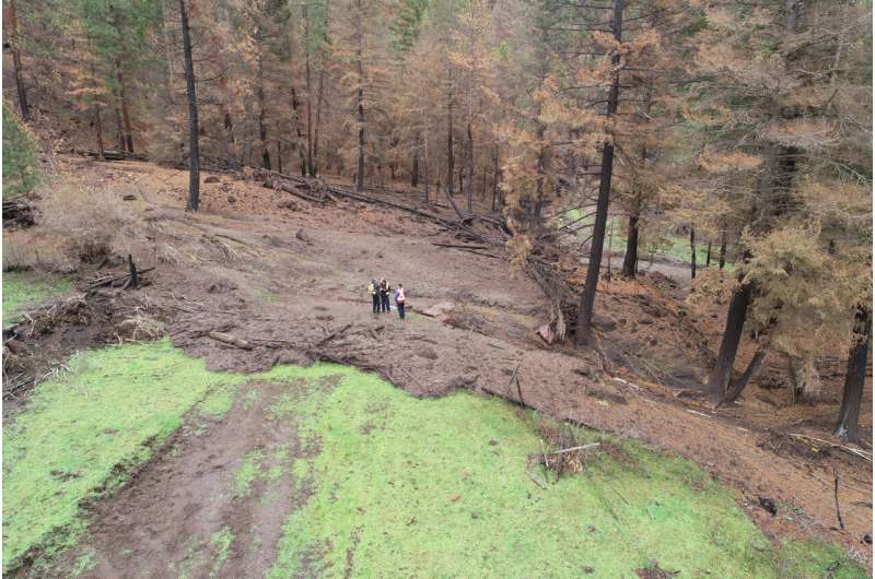
Members of the Nicomen Indian Band discuss how their land and water supply has been negatively affected by post-wildfire debris flows with representatives from the Ministry of Forests and UBC Okanagan. Credit: Dwayne Tannant.
by University of British Columbia
August 26, 2024
It took more than 25 years for Rhonda MacDonald and her family to transform their 41-hectare property on the Shackan Indian Band Lands, south of Merritt, BC, into a vibrant business and homestead—but a massive 2022 debris flow changed everything in just 25 minutes.
“It was too fast to even comprehend,” explains MacDonald, who runs a ranching and hay business on the property with her husband, Wayne.
“I remember when it was over, I was futilely trying to save our yard with the bobcat, and then I just stopped and looked at what used to be our hay field. My mouth dropped open. I couldn’t wrap my head around the devastation.”
After the mudslide, eight hectares of land were covered in several feet of mud, rock, debris and garbage. Cleaning the property has been a massive, years-long undertaking for MacDonald and her husband.
“I think one of the hardest things for me to accept is that my property isn’t the beautiful, pristine piece of land it once was,” MacDonald muses sadly.
Turning devastation into data
“Stories like Rhonda’s don’t make the news because these types of debris flows rarely impact large urban populations. But they disproportionately impact First Nations communities and rural residents, especially in southern British Columbia,” says Kaushal Gnyawali, a civil engineering doctoral student at UBC Okanagan.
He adds that as climate change becomes more intense, it will undoubtedly continue creating more powerful weather systems causing widespread wildfires and subsequent post-wildfire debris flows.
“Every year, we pass the previous year’s record for total area burned. These fires have scarred the landscape and pre-conditioned it to debris flows, which not only impact people living in rural areas, but also highways, railways, pipelines, water supply and aquatic ecosystems.”
That’s where Gnyawali and his doctoral supervisor, Dr. Dwayne Tannant—an industry leader in mitigation strategies—are involved. They study how to manage small—but no less damaging—debris flows in BC’s interior; their methods can eventually be applied to debris flows globally.
Over the past 10 years, approximately 407,000 hectares have been burned by wildfires in British Columbia. While Gnyawali’s research primarily encapsulates three biogeoclimatic zones of bunchgrass, ponderosa pine and Douglas fir, which are common in the Okanagan, his research results also apply to other areas of steep terrain in western Alberta and the Yukon.
Crucial to Gnyawali and Dr. Tannant’s work are the partnerships with First Nations communities in the BC Interior and Okanagan Valley, rural residents like the MacDonalds, the BC Ministry of Forests, and engineering service companies Clarke Geoscience Ltd. and Stantec.
Whether providing video or oral accounts of debris flows or offering physical access to impacted areas, the partnerships ensure Gnyawali has the data he needs to devise long-term solutions.
“Through photos and videos from residents experiencing these landslides, I’m able to conduct a forensic analysis of what happened in the area,” explains Gnyawali. “When someone calls me about a mudslide, I visit as soon as I can to map the topography with my drone, which helps me create 3D models of the area.”
Crucial to his work is understanding the mitigation strategies of First Nations communities in response to post-wildfire debris flows. These include cleaning small streams that flow only briefly during and after a rainfall, and constructing simple ditches and berms.
Based on the various pieces of information captured about the debris flows, Gnyawali eventually recreates flow simulations on a computer using high-resolution topography data and rainfall intensities.
He trains his computer model to understand what happened in the past so it can better predict what might happen in a future influenced by climate change. These efforts culminate in developing a rationale to design effective mitigations in these environments and simple guidelines to increase public safety.
“Growing up in Nepal, I understand how devastating a landslide can be. I’ve been stranded for days on a highway because of multiple large mudslides; I’ve seen them sweeping villages and blocking rivers.”

It was ultimately the 2015 Gorkha earthquake, which triggered more than 20,000 landslides and uncountable cascading disasters, that ignited Gnyawali’s passion for studying geohazards.
“I need to do something to solve this problem by focusing on solutions, and outside of Nepal, the Okanagan is the best place to live and to study these events.”
Public Scholars Initiative enables community-based research
Aside from generating a first-of-its-kind data set about debris flows for the Okanagan region, Gnyawali’s doctorate is unique as part of UBC Okanagan’s Public Scholars Initiative.
Starting in 2015 at UBC Vancouver and launched in 2022 in the Okanagan, Public Scholars Initiative research has a tangible impact on the public good through collaborative, action-oriented forms of scholarship.
In Gnyawali’s case, while various partners provide him with invaluable information to advance his research, he’s also able to provide them with his own expansive data and analysis which can help plan for future debris flows.